
California Statewide Potential Brownfields Inventory

Supporting Environmental Justice, Community Revitalization, and Equitable Redevelopment
Brownfields are properties where redevelopment or reuse may be complicated by the presence or potential presence of contamination. Brownfields are often concentrated in communities already burdened by pollution, disinvestment, and environmental injustice.
Addressing brownfields can help communities:
- Improve environmental and public health
- Support affordable housing and infill development
- Increase access to parks, transit, and community amenities
- Promote climate resilience and smart growth
- Revitalize underutilized land
- Reduce pressure for sprawl and greenfield development
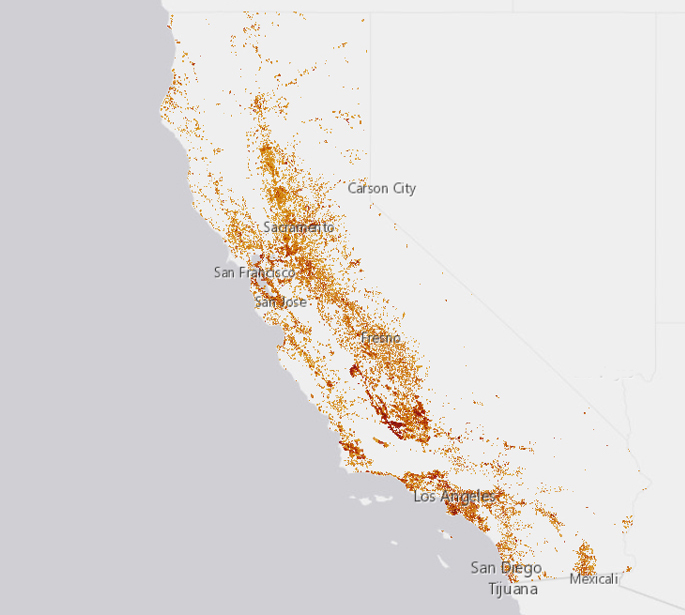
- First-of-its-kind screening tool to identify parcels across California that may be impacted by historic or ongoing contamination and may face barriers to redevelopment
- Developed using publicly available environmental, land use, and business activity datasets to help communities better understand the scale and distribution of potential brownfields statewide
- Approximately 396,633 potential brownfield parcels have been identified across California — representing about 3.7% of all parcels statewide.
- Intended as a screening-level resource to support planning, environmental justice initiatives, community revitalization, research, and funding applications
- Does not confirm contamination at any specific parcel and should not replace site-specific environmental investigation.
Addressing brownfields can help communities:
- Improve environmental and public health
- Support affordable housing and infill development
- Increase access to parks, transit, and community amenities
- Promote climate resilience and smart growth
- Revitalize underutilized land
- Reduce pressure for sprawl and greenfield development
For this project, potential brownfields were identified using a statewide screening methodology that combined publicly available environmental, land use, and business activity datasets. The inventory was developed using information on:
- Known environmental cleanup and contamination sites
- Hazardous waste and pollution records
- Oil and gas infrastructure
- Industrial and potentially contaminating business activities
- Vacant and underutilized parcels
- Historic and current land uses associated with contamination risk
The methodology relies on existing databases of environmental concern to identify parcels that may have known contamination or conditions associated with perceived contamination and redevelopment barriers.
The inventory combines multiple statewide datasets related to:
- Known environmental cleanup sites
- Hazardous waste and contamination records
- Industrial and potentially contaminating land uses
- Oil and gas infrastructure
- Vacant and underutilized parcels
- Proximity to sensitive land uses and disadvantaged communities
The accompanying dataset also includes parcel-level indicators related to:
- Environmental justice status
- Transit access
- Sensitive land uses
- Flood and wildfire risk
- Affordable housing opportunity areas
- Potential redevelopment suitability
- State Agencies
- Cities, counties, regional agencies, transit agencies, and special districts
- Advocacy groups
- Researchers and academic institutions
The tool can help grant applicants demonstrate environmental burden and community need for federal and state funding opportunities, including:
- U.S. EPA Brownfields Program
- California DTSC Equitable Community Resilience Grants
- Environmental Justice Action Grants
- Urban Greening Programs
- Climate and infrastructure funding initiatives
The database provides screening-level information that applicants can use to:
- Describe community conditions
- Document potential environmental justice impacts
- Support redevelopment and remediation proposals
- Complement local knowledge and community-based data
Brownfields Explorer
Learn more about Brownfields in California. Use our mapping tool to explore locations and types of properties that exist.
Please Note: This inventory is a screening tool only. Parcels identified as potential brownfields
may or may not contain contamination. Additional environmental assessment and community-based
investigation are necessary before redevelopment or cleanup decisions are made.
Reports
- Swayne, M., Sadd, J., Barlow, J., Twyman, M., McKinstry, C., & Woo, J. (2024). Statewide potential brownfields count - Technical report and methodology. California Department of Toxic Substances Control, Statewide Inventory of Brownfields in California. DTSC Agreement: 22-T5092.
- Swayne, M., Sadd, J., Barlow, J., Twyman, M., McKinstry, C., & Woo, J. (2025). Statewide potential brownfields count - Expanded inventory and online screening tool - Technical memorandum. California Department of Toxic Substances Control, Statewide Inventory of Brownfields in California. DTSC Agreement: 22-T5092.
Project Team

Dr. Madison Swayne
Lead Investigator
Email: [email protected]

Dr. James Sadd
Investigator
Email: [email protected]

Dr. Jessica Barlow
Investigator
Email: [email protected]

Carson McKinstry
GIS Technician
Email: [email protected]

Matthew Twyman
GIS Technician
Email: [email protected]

Jason Woo
GIS Technician
Email: [email protected]
Contact Us
Have a question? You can contact us at [email protected].
Acknowledgments
This work was supported in part by a contract from the California Department of Toxic Substances Control to the San Diego State University Research Foundation, 22-T5092.
The team would also like to thank Bhanu Bade for his support in developing the Brownfields Explorer Dashboard.